Midnite Mine, Wellpinit, Washington
Geologic Shell Model (GSM) for the Midnite Mine (Under Construction)
The geologic shell model (GSM) consists of 14 filterable layers that can be viewed/modified using AutoCad Release 13. The term “shell” as used herein
is a three dimensional feature bounded by irregular surfaces. A shell differs from a solid in that no data are present within or linked to the interior of each shell.
The GSM consists of four shells: (1) granite (pink), (2) calc-silicate (lime green), (3) schist (light blue), and (4) alluvium (yellow) Each shell is composed of three filterable surfaces: (1) top, (2) bottom, and (3) skirt.
The horizontal discretization of the GSM is a whole number multiple of that of the ground water flow model (GWFM).
The drainage basin boundary that encompasses the site is used as the vertical boundary. A planer boundary that is much lower in elevation than Blue-Creek is used as the
basal boundary. The existing topography is used as the upper boundary of the GSM.
Each of the four shells of the GSM are generated as follows. Topographic maps of each upper horizontal surface (TOP) are obtained from an ARC/INFO
Geographic Information System (GIS) via *.DXF files. Each map is converted to 3D-Faces using QUAD.EXE (Rockware). The 3D-Faces are trimmed to
the site boundary and lithologic boundaries using AutoCad. Layers are copied in instances where the surface of the top of one unit is the same as the
surface of the bottom of the overlying unit. Finally, a program was written to add the 3D-Faces that connect the upper and lower surfaces of a single
shell.
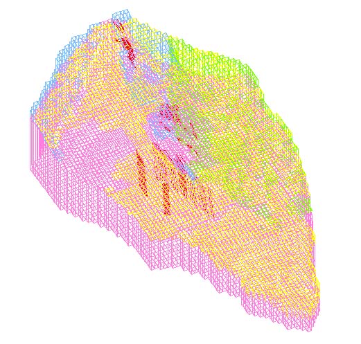
Wire-frame GSM model of the site looking northwest showing granite (pink), calc-silicate (lime green), schist (light blue), alluvium (yellow) , faults (red)
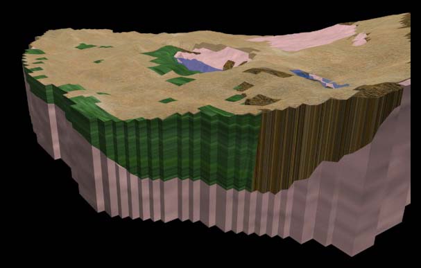
Rendered GSM captured from animation produced using 3D Studio showing granite (pink), calc-silicate (marbled green), schist (chocolate brown),
alluvium (brown) , and water (blue).
Return to AESE